 |
LIFETIME of WALKS by DEREK HARWOODDerek Harwood's Walking Records If you have any queries about the pictures or descriptions e-mail me at: derek@harwoodonline.com | ||||||
 | |||||||
| Lands End to John o'Groats Fill-in Path
Bettyhill to Strathy Saturday 30th June 2018 ..................................Walk No. 1182 |
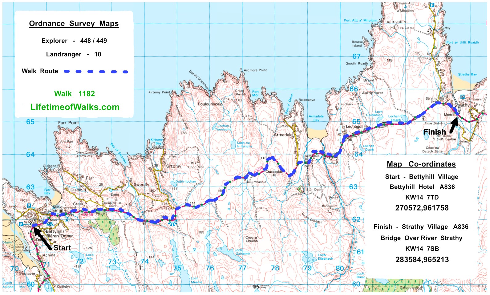 | ||||||
Lands End to John o'Groats Fill-in No. 55  Total 499.5 miles


Time Taken:  5:00 hrs               Distance:                Enjoyment:          Weather: Sunny
 09:00 am - 14:05 pm                10.0 miles                      95%                    Very Windy

Temp:      Cloud:        Rain:       Visibility:        Ground Conditions:               Nature:
 25oC         10%           0%            Good                     Tarmac              Very Few Midges

Total AA:            Total MH:       Total LD:         Total AW:         Other:        Total Distance:
 1126.5 mls        976.0 mls     3767.0 mls     174.5.0 mls    2002.0 mls     8051.0 miles

Companions:  (Derek)

Points of Interest and LINKS:
Land's End to John o' Groats		Alness River      		Cromarty Firth
Inverness    					Great Glen Way
Description:
The weather forecast was for another lovely day. How lucky was I! I strode out of the Hotel and into the sunshine, with a bounce in my step. Looking over my shoulder for a last glimpse of the beautiful estuary & Torrisdale Bay, I walked down the hill passing the Public Toilets and the Bus Stop. I soon came to a sighting of Farr Bay, another beautiful sight in the sunshine. My camera was in action already. At the bottom of the hill, I came to a signpost, pointing the way to Strathnaver Museum, Farr Stone, Strathnaver Trail, (which I walked the previous day), and the Information Centre with a Caf�. All a must if time allows. I visited the Information Centre and regretted not having time to see the other attractions. However, whenever a bus timetable is to be used, it is better to have as much time as possible, especially at the start of the walk. I continued up the valley on the main road, A836, a narrow valley with steep rocky sides to a pleasant wide valley and a junction with the village road leading to the villages of Crask and Farr. The road was relatively flat until after Loch Salachaidh, when it became undulating with steep up and down sections. This continued until the plateau of Cnot Mor was reached. Here the landscape was very barren. The road could be seen disappearing way into the distance! Near the parking area and a wind turbine, I turned round and looked west for a change. To my surprise I could clearly see the majestic mountain of Ben Hope. It was very prominent on the skyline and a delight to see. Other mountains could be seen in the far distance but not distinct enough for me to recognize. At one point after the parking area, I passed a lone bus shelter, letter box and a 'For Sale' sign. It was impossible to determine which of the shelter, the letter box, or the Moor was for sale. Perhaps it was a combination of the three. At the eastern end of the plateau the road obviously started to decline, but meandered down in very broad sweeps, giving great views across to Port Chinn Bay, and the village of Armadale, with Armadale Bay in the distance. The view of Armadale Bay was delightful, especially with the distant Orkney Isles on the horizon. At the bottom of the valley I crossed Allt Beag but before I reached Armadale Burn, I passed Armadale House, Farr North Coast B&B, Scotland. This was my next Accommodation, starting that evening. I strode past the house and continued towards Strathy. When I came to Armadale Burn I noticed a picnic area with table and the original stone bridge over the burn. This bridge would have been used by pre-motor traffic. I slowly climbed out of the Armadale Valley on the A836 main road, passing Loch Gainmhich and Lochan Ealach, both on the north side of the road. I passed the Brawl Road, again on the north side of the A836, as a convoy of motorcycles passed. They weren't travelling fast but they weren't going slowly either. This wasn't a surprise for me because I was walking on the 'Highland's Circular 500 Route', and this was occurring several times a day on the North Coast Road. The 500 Route is 500 miles around the far north of Scotland. Besides motorcycles, there were often a small group of cyclists passing me, but never other walkers. This was a surprise for me, because I was expecting to chat to other walkers. Perhaps they used the A9 route. My philosophy was not to walk on roads, but walk along ways, footpaths or trails as much as possible. This was mostly true in England, but difficult in Scotland with a limited time schedule. It was extra difficult in Scotland for me because of the 'Right to Roam' law. There are very few footpaths in the direction I wanted to go. For example, I was walking along a lane and asked a local if I could get through to another lane. The OS map was not clear. There are no farm gates illustrated on the best possible maps. I was told she wasn't sure but thought it was possible. I proceeded and found that I had walked along all the hedgerows of a field to arrive back at the same farm gate! I did get through eventually but it was far too time consuming. The only way was to camp and take far more days to get to my destination. I have often camped out in the past, but this has to be planned and is much easier if I were following footpaths, Ways or Trails. Also if a public footpath is being followed, the walker knows the route is passable, except in bad weather conditions. Approximately half of the distance walked in Scotland had been along Ways or Trails, e.g. Large part of St Cuthbert's Way, small part of Southern Uplands Way, Union Canal, Large part of the Clyde � Forth Canal, whole of the West Highland Way and the whole of the Great Glen Way. Beyond Inverness I walked along lanes wherever possible. To keep away from the A9 Trunk Road I walked north through central Scotland to the North Coast. Then I travelled along the North Coast to John o' Groats. This added many miles to the walk, but every mile was enjoyable and an 'Adventure', as I found to my satisfaction. After the Brawl Road junction on the A836 road towards Reay Village, I passed Lighthouse Road, which led to Strathy Point Lighthouse. I passed the road junction and Strathy Inn while enjoying the wide open view of Strathy Bay, including more views across the sea to The Orkney Isles. The road turned slightly inland towards the River Strathy road bridge, where I planned to catch the bus back to Bettyhill and my parked car. Unfortunately when I checked the bus timetable and my watch, I discovered that I had approximately two hours to wait. I looked around and discovered I was standing next to the Strathy, Victoria Public Hall. I wondered around for a little while, until I decided to go into the Public Hall to explore. As I passed through the door I was welcomed by the players of the local indoor bowls clubs. All the bowlers were competing against each other to win the local league trophy. I explained what I was doing and they welcomed me into the mess room for a cup of tea. It would have been rude to turn the offer down so I agreed with open arms. I went into the main hall and watched the ladies and gentlemen playing their bowls. The time soon passed until it was time to wait for the bus at the bus stop. I thanked everyone for their hospitality and ventured outside into the sunshine to wait for the bus. I was pleased to see the bus appear in the distance, so I hopped on when it stopped to enjoy the ride along the route I had just walked. I drove my car from Bettyhill Village to the accommodation. Yet another wonderful day's walking in the Scottish sunshine. A very memorable day, recommended. Enjoy but be very careful of the traffic.
Location Map: -
www.streetmap.co.uk,
Start: at KW14 7TD - Bettyhill Hotel, North Coast, Highlands Finish: at KW14 7SB - River Strathy Bridge, North Coast, Highlands Click Here for Previous Walk on the Fill-In Walk - Walk 1181 Click Here for Next Walk on the Fill-In Walk - Walk 1183 Click Here to Return to 'Lifetime of Walks' Homepage | |||||||
 | |||||||
 | |||||||
 | |||||||
 | |||||||
 | |||||||
 | |||||||
 | |||||||
 | |||||||
 | |||||||
 | |||||||
 |
|||||||
 |
|||||||
 |
|||||||
 |
|||||||
 | |||||||
 |
|||||||
 |
|||||||
 |
|||||||
 |
|||||||
 | |||||||
 |
 |
 |
 |
 | |||
 |
 |
 |
 |
 | |||
| Previous Walk : Next Walk : More Photos : Favourite Walk : 'Lake District' Photos | |||||
| News : Formula 1 : Walking : Table Tennis : Bellringing : My Friends : My Guestbook : CV : Links | |||||
Derek Harwood: Copyright 2009 Revised: May 2023 | |||||