
 |
LIFETIME of WALKS by DEREK HARWOODDerek Harwood's Walking Records If you have any queries about the pictures or descriptions e-mail me at: derek@harwoodonline.com | ||||
 | |||||
| HEART OF ENGLAND WAY Dorsington to Mickleton Monday 21st July 2008 ....................................Walk No. 719 |
 | ||||
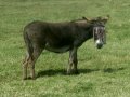
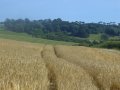
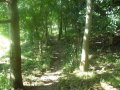
HEART OF ENGLAND WAY  No. 11         Total 85.5 miles


Time Taken:  3 hrs         Distance:      Enjoyment:      Weather:   Warm & Sunny
 1:30 pm - 4:35 pm            6 miles              85%                      Breezy

Temp:    Cloud:      Rain:    Visibility:   Ground Conditions:  Wild Life:   Donkey
 21oC        25%       None     Very Good       Excellent              Horses,  Butterflies

Total AA:      Total MH:    Total LD:       Total AW:     Other:       Total Distance:
 1027.5 mls    931.5 mls     1909 mls        162 mls     1195.5 mls      5225.5 miles

Companions:  (Derek)

Points of Interest and LINKS:
Heart of England Way                       Dorsington Village                    Long Marston
National Cycle Network                    Stratford Greenway                 Monarch's Way
Bulldog Bash                                      Lower Quinton                   Vale of Evesham
Meon Hill Fort                                   Mickleton Village
Description:
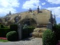
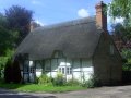
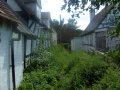
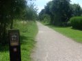
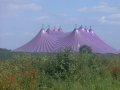
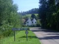
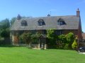
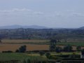
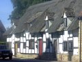
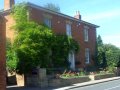
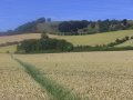
Parked in Back Lane Mickleton at 12:45pm and started cycling to Dorsington Village, via Broad Marston Road to Pebworth, then Dorsington Road, to arrive at 13:30pm. Three quarters of an hour cycling. Another northernly wind, always against the wind when cycling along the Heart of England Way. Locked cycle to fence and started walking to Mickleton. What a sad society we live in when we have to continually worry about the security of our hard earned property. Way overgrown along Holeham Brook from start of walk to Long Marston. Path visible but flora very tall at height of the growing season. Official way crosses the corner of a horses field for 10 metres just before Long Marston. Easy to walk around the corner of the field to prevent disturbing the horses. I'm chicken really. Smart houses along Wyre Lane, Long Marston to Strafford Greenway. Memories of recent walk. See Walk 716. Delightful walk past ponds to edge of Long Marston Airfield. Here the Way becomes a narrow path around 'Doctor's Farm'. Beware of pot holes hidden by vegetation along this narrow path. Crossed the busy B4632 road and continued into Lower Quinton Village. Road extremely busy during the Bulldog Bash. Short walk along Goose Lane to Upper Quinton and its huge village green. Passed a house unusually named 'Itlldo', or 'It will do', on Hill Lane. After the village the path crosses an ancient ridged and furrow field, the result of a system of ploughing used in the Middle Ages. As Meon Hill is skirted, there are good views across the Vale to Evesham to Bredon Hill and the Malvern Hills. Steady descent through the corn fields to Gran Brook and the county of Gloucestershire. Short walk into Mickleton with the beautiful backdrop of the Cotswolds Hills.
Location Map: -
www.streetmap.co.uk, -
Start: from Dorsington Village 413408/249798, -
Finish: at Mickleton Village 416123/243832, -
via: Lower Quinton 417800/247145. (Click on location and use Zoom and BACK Buttons).
Hazards: Always follow map carefully. Care required north of Long Marston, path may be overgrown in high summer. Care also required at Upper Quinton to follow road to top side of houses before skirting footpath around Meon Hill. Click Here to Return to 'Lifetime of Walks' Homepage | |||||
 | |||||
 | |||||
 |
|||||
 |
|||||
| |||||
 | |||||
 | |||||
 | |||||
 |
|||||
 |
|||||
 |
|||||
 |
 |
 |
 |
 |
|
| Previous Walk : Next Walk : More Photos : 'Midland Hillwalking' Photos : 'Lake District' Photos | |||||
| News : Formula 1 : Walking : Table Tennis : Bellringing : My Friends : My Guestbook : CV : Links | |||||
Derek Harwood: Copyright 2009 Devised: March 2009 | |||||