 |
LIFETIME of WALKS by DEREK HARWOODDerek Harwood's Walking Records If you have any queries about the pictures or descriptions e-mail me at: derek@harwoodonline.com | ||||||
 | |||||||
| Lands End to John o'Groats Fill-in Path
Whitebridge to John o'Groats Sunday 29th July 2018 .....................................Walk No. 1186 |
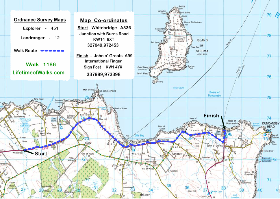 | ||||||
Lands End to John o'Groats Fill-in No. 59  Total 533.5 miles


Time Taken:  3:25 hrs               Distance:                Enjoyment:          Weather: Sunny
 10:00 am - 13:20 pm                8.5 miles                      90%                 and Very Windy

Temp:      Cloud:        Rain:       Visibility:        Ground Conditions:               Nature:
 18oC         15%           0%            Good                     Tarmac                        No Midges

Total AA:            Total MH:       Total LD:         Total AW:         Other:        Total Distance:
 1126.5 mls        976.0 mls     3813.0 mls       174.5.0 mls    2009.5 mls     8099.5 miles

Companions:  (Derek)

Points of Interest and LINKS:
Land's End to John o' Groats		Thurso Town      			Caithness County
Boars of Duncansby    			North Highlands, Scotland    	John o'Groats
Description:
From the accommodation (Thurso House) I travelled in convoy to John o' Groats, with the Landlord & Landlady in their car, and me in my car. The Landlady had very kindly offered to drive me from John o' Groats to the start of the walk at Whitebridge, because it was a Sunday and no buses were running. I planned walking on the Sunday because it had the best weather window, with no rain forecast until after 2pm. At John o' Groats I transferred my walking equipment etc., from my car to their car, and they drove me to Whitebridge (near Mey Castle), the junction of the A836 and the minor road (Burn Road) towards Scarfskerry Village. I waved bye to the kindly couple as they drove off for their picnic by the sea. As it was so fiercely windy I immediately searched through my rucksack for my hat with a chinstrap because I had lost a few caps in the past due to the strong wind. I had planned to start walking at 9am rather than 10am as it was then. I was ready to leave the accommodation at 8am but had to wait until they were ready. I waited an hour, but as they were doing me a big favour, I just had to wait patiently, knowing the weather would deteriorate after 2pm. I started my last day's walking on the Land's End to John o' Groats Adventure from the low point near the Burn of Rattar, and slowly walked uphill, following the A836 towards East Mey. As I approached the Castle of Mey, which the Queen Mother had bought, in Mey Village, I noticed that all the Castle Road Signs were covered and the castle entrance had a sign 'Castle Closed'. Apparently the Duke and Duchess of Cornwall, or Prince Charles & Camilla, were staying at the castle for a week's holiday, so the castle was closed to the General Public. I took a photo of the driveway to the castle, with an arch of trees near the Castle Gates. I walked onwards in the sunshine and wind up the hill to East Mey, where the panoramic views of Dunnet Head Cliffs and the hazy Orkney Isles in the far distance were slowly unfolding. I kept looking over the dry stone wall towards the castle without any luck for a while, but eventually the top of the castle could be seen. I used my camera with a good telephoto lens to get a respectable shot of the castle with the Prince's Flag flying stiffly in the strong wind from the top of the tower. The scene was magnificent. I passed a small fenced off area around a very interesting old hand water pump on the right before Greag Namara Guest House and near the summit of the hill. At the crest of the hill the sight of Pentland Firth, Stroma Island and the Orkney Isles were magnificently laid out around me. But very strangely the Boars of Duncansby were very visible and intriguing, with a definite patch of the sea with very rough white water, or 'white horses'. I later learnt that this stretch of water is famous for its tidal race that flows like a river through the sea. Any boat without full power is soon swept away in the tremendous currents that flow particularly when there is also a storm in full force. I was obviously observing the boar at the turn of the tide because the sight was almost unique. The road slowly turned a right bend and and then an 'S' bend, before the long straight road downhill to the Pier Road in Gills Hamlet. The short road, as the name implies, was the access to the Pentland Vehicle Ferry at the pier in Gills Bay. As I walked onwards I passed some Shetland Ponies near Heather Bell, a car park or lay-by and some gorgeous new country houses. Here I saw more good views of the low lying Island of Stroma in the Pentland Firth and the 'White Horses' of the racing tide passing 'Skerry', the southern tip of Stroma. Further along the coast I came to Canisbay Church of Scotland & its cemetary. The church was very unusual as its tower had virtually no windows and a conventional sloping roof. As it was noon and the service was starting, I wondered if Charles and Camilla were attending. I walked slowly on and loitered by the cemetery but I didn't see the Royals. The cemetery was typical of Caithness with chess piece like memorials instead of 'head stones' at each grave. I could see lots of pawns, bishops and castles, with the odd king and queen, but no knight or horse. As I walked on past a couple of fields, would you believe I came across some horses. Apart from the couple of Shetland Ponies I saw earlier this was unusual because all the livestock I had seen were either sheep or cattle. The next point of interest was in the small hamlet of Huna. As the A836 main road turned to the right around a slow bend, a minor road continued straight to Huna House. At this road junction there were several cottages and surprisingly an old red telephone box near a red letter box. The door of the telephone box was wide open, inviting anyone to buy some produce from the shelves. I was not tempted but I'm sure many people would be. A couple of bends later I came across some old mill buildings, the rear of which made a good traditional picture of life as it was centuries ago, emphasized by the pack horse humpback bridge. From this point I looked across about half a dozen fields to the Hotel of John o' Groats, by the ferry terminal. I could see my final goal easily in the distance. and also at this point I was beginning to get emotional, the end of my epic walk. I continued walking down the straight road of the A836 to the A99, where the road signs read 'John o' Groats � of a mile' and 'Wick 17 miles'. A sharp turn left onto the A99 and I was nearly there. The emotion was mounting as I passed my car in the car park and headed straight for the Directional Finger Post. I had finished!After all the planning, the logistics of getting around the countryside back to the car, hotel, etc. All that was left were the celebrations. The finger post pointed in the appropriate direction, as the crow flies, with Land's End 874 miles, New York 3230 miles, Edinburgh 273 miles etc. At this point I very strangely became very emotional. All my efforts were suddenly over and I had lost something. I was soon back in the cheering mode when a young man took some photos of me for future memories. I did really miss not having someone there to celebrate with me to enjoy the moment together. I waited around for a while to see if there were anyone in a similar situation as me so we could celebrate together, but no-one. I slowly walked to the caf� with my camera full of memories and ordered a cup of tea (no alcohol, I was driving). I explained to the assistant what I had achieved, and she could see the emotion, so she said the tea was free. I was amazed, I didn't say anything but I thought I deserved two cups which I had before I left the caf�. Suitably refreshed I went to the souvenier shop, bought a fridge magnet and signed the 'Land's End � John o' Groats Book'. After deliberations, I decided to visit the local sights. The expected rain and cloud was approaching fast, so the photos of Duncanby Head and Dunnet Head were dull and poor. With a spare day before the long journey home, I decided to re-visit the sights again the next day. Yes! What a day, never to be forgotten. A very special day to add to a 'Lifetime of Memories'.
Location Map: -
www.streetmap.co.uk, -
Start: at KW14 8XT - Whitebridge Road Junction on A836, & Burn Road, by Celtic Lodges and Burn of Rattar.
Finish: at KW14 4YX - John o' Groats, at the International Finger Sign Post
Click Here for Previous Walk on the Fill-In Walk - Walk 1185 Click Here to Return to 'Lifetime of Walks' Homepage | |||||||
 | |||||||
| |||||||
| |||||||
| |||||||
| |||||||
| |||||||
| |||||||
| |||||||
|
|||||||
| |||||||
| |||||||
| |||||||
| |||||||
| |||||||
| |||||||
| |||||||
| |||||||
| |||||||
| |||||||
| |||||||
| |||||||
| |||||||
| |||||||
| |||||||
|
|
|
|
| |||
|
|
|
|
|
|||
| Previous Walk : Next Walk : More Photos : Favourite Walk : 'Lake District' Photos | |||||
| News : Formula 1 : Walking : Table Tennis : Bellringing : My Friends : My Guestbook : CV : Links | |||||
Derek Harwood: Copyright 2009 Revised: June 2024 | |||||